BIM Modelling & 3D Visualization
In today's advanced construction and property sectors, raw data from surveys is only the beginning. The true value is unlocked when this data is transformed into intelligent, actionable digital models. Building Information Modeling (BIM) and 3D visualization provide the framework for deeper analysis, enhanced collaboration, and smarter decision-making throughout an asset's entire lifecycle. Please note: Our BIM & 3D Modelling services are offered exclusively as a value-add for clients utilizing our Drone Surveying and 360° Site Inspection data acquisition services. This integrated approach ensures that the models we create are built upon a foundation of unparalleled accuracy—the reality we capture ourselves. As an official partner of SIGNAX, we are uniquely positioned to not only create these intelligent models but to ensure they are seamlessly integrated into a leading Common Data Environment (CDE), making your data accessible, collaborative, and powerful.
Our Integrated BIM & 3D Modelling Services
We transform the high-fidelity data we capture into intelligent assets that fuel your project workflows.
Scan-to-BIM & As-Built Modelling
Creating intelligent digital twins from reality captured through our data acquisition services.
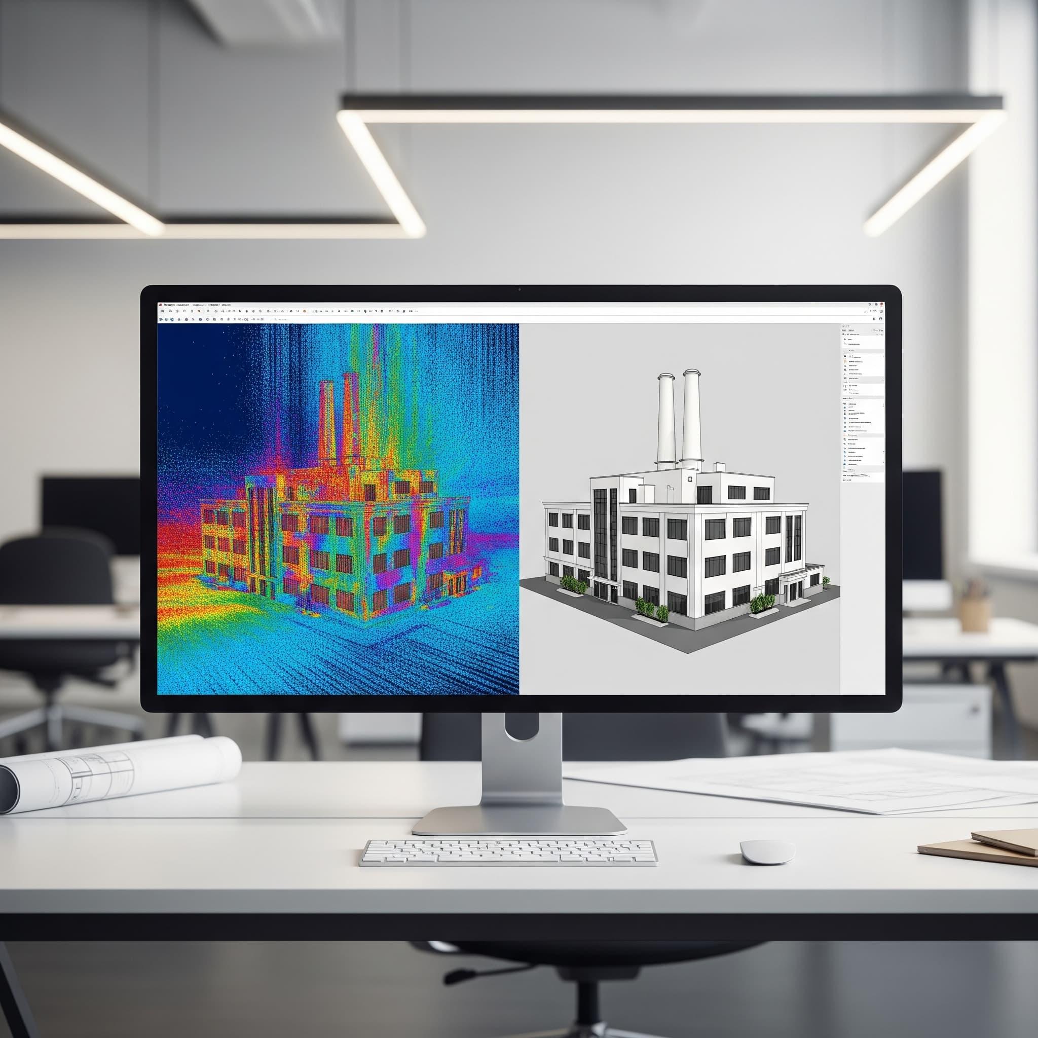
Scan-to-BIM & As-Built Modelling (from Our Data): This is the foundational process of creating an intelligent digital twin from reality. We convert the precise point clouds from our drone surveys into accurate, object-rich BIM models that reflect the true as-built conditions of your site, building, or masterplan.
Enhanced BIM for Operations
Enriching models with operational data for long-term facility management and SIGNAX integration.
BIM Data Enhancement for Facilities Management (for SIGNAX): An as-built model is just the start. We enrich these models with critical asset information, maintenance schedules, and operational data, transforming them into powerful tools for long-term facility management. This service is optimized for seamless integration with the SIGNAX CDE.
Planning & Design Support
Providing accurate digital foundations for architectural and planning workflows.
Existing Conditions 3D Modelling for Planning: For initial planning and design stages, we create highly accurate, measurable 3D models (meshes and terrain models) of existing sites. This provides architects and planners with a precise digital canvas to build upon, de-risking the design phase from the outset.
Why Choose Our Integrated Data-to-Model Service?
Guaranteed Accuracy: Because we control the data capture process, we can guarantee the accuracy of the foundational data, which directly translates to a more reliable and precise final model.
Seamless Workflow: Our integrated process eliminates the friction and potential for error that comes from handing off data between a surveyor and a separate modeling firm.
Single Point of Contact: You have one expert partner responsible for the entire workflow, from capturing reality on-site to delivering an intelligent, CDE-ready digital model.
Deep Expertise: We understand not just how to capture data, but how that data needs to be structured and processed to create high-quality, usable BIM and 3D models for our key sectors.
Our Partnership with SIGNAX: Your Collaborative Advantage
Centralized
A single source of truth for all project stakeholders.
Accessible
Easily view and interact with models and documentation from any device, including mobiles in the field.
Version Controlled
Ensuring everyone is working from the latest information.
Secure
Hosted in a robust and secure cloud environment.
Frequently Asked Questions (FAQ) about BIM & 3D Modelling
Our BIM & 3D Modelling services are exclusively offered as an add-on to our core data acquisition services. We believe the most accurate and valuable models are built from data we capture ourselves, as this ensures a seamless, high-integrity workflow from start to finish.
A 3D model accurately represents the shape and geometry of an object (what it looks like). A BIM (Building Information Modeling) model is an intelligent 3D model that, in addition to geometry, contains layers of data and information about the objects within it (what it is, what it's made of, its specifications, etc.).
LOD refers to how much detailed information is included in a BIM model's elements. A lower LOD (e.g., LOD 200) might show a wall as a simple shape, while a higher LOD (e.g., LOD 400) might include every layer of that wall, from studs to finishes. We tailor the LOD to your specific project needs.
It provides a direct, optimized path to hosting your project's data in a leading Common Data Environment. This ensures all your stakeholders can easily access, share, and collaborate on the models and documentation we create, from anywhere, on any device.
We use a range of industry-leading software, including Autodesk Revit, to create our BIM models. We deliver the final models in standard, interoperable formats like .RVT and .IFC to ensure they are compatible with your existing workflows and software.