GCAA-Approved Drone Surveying & Aerial Mapping
In the ambitious landscape of the United Arab Emirates, where project delays are costly and precision is non-negotiable, traditional surveying methods no longer provide the certainty required. To de-risk multi-million dirham projects, you need more than just data; you need unimpeachable intelligence. Ayn al Taqniya is your strategic data partner. As a GCAA-certified drone operator, we specialize in acquiring high-resolution, survey-grade aerial data that empowers your projects with unparalleled clarity and accuracy. We don't just fly drones; we deliver the irrefutable data foundation that makes your engineering reports defensible and your project decisions bankable.
Our Suite of Drone Data Acquisition Services
Our expertise covers a wide range of applications, each designed to solve specific industry challenges by providing the critical data that fuels your analysis, planning, and execution.
Construction & Development Data
Comprehensive data solutions for construction and development projects
Construction Progress Monitoring: Keep your project on schedule and within budget. We provide the objective, verifiable data you need to compare as-built reality with BIM designs, verify contractor work for payment applications, and resolve disputes with a definitive timestamped record of your site.
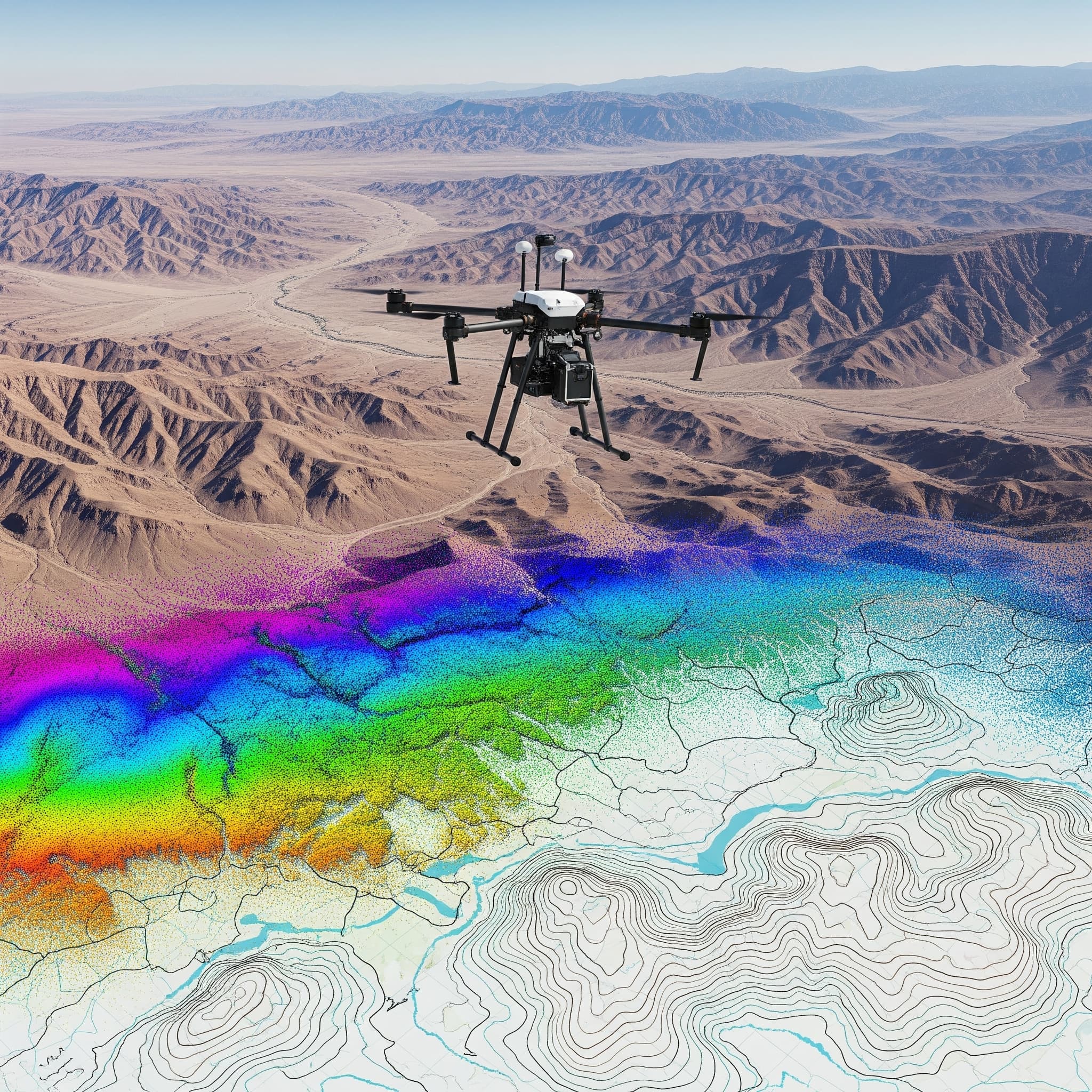
Topographic & As-Built Surveys: Base your engineering and design decisions on reliable, precise information. We utilize advanced RTK/PPK-enabled drones to capture survey-grade data with sub-centimeter accuracy for land development, infrastructure planning, and as-built verification.
Stockpile Volumetric Analysis: Get fast, accurate, and safe volume calculations for stockpiles, quarries, and earthworks. Our drone data provides precise measurements to manage inventory and resources effectively, eliminating hazardous manual measurements.
Building & Asset Integrity Data
Detailed assessment data for building and asset management
Data for Building Condition Assessments: Mitigate risk and inform capital planning with a complete digital record of your asset. Our drones capture high-resolution visual and thermal data of the entire building envelope, enabling your engineers to identify structural defects before they escalate.
Data for Facade Inspection & Analysis: Ensure the integrity and safety of complex facade systems. We provide forensically-detailed data to analyze cladding, glazing, and curtain walls, helping your team assess compliance with the UAE Fire and Life Safety Code.
Energy & Infrastructure Data
Specialized data acquisition for energy and infrastructure sectors
Data for Energy Asset Integrity: Maximize uptime and improve safety in the energy sector. We provide specialized data for inspecting vast solar farms, towering wind turbines, and critical oil and gas facilities like live flare stacks, powering your predictive maintenance programs.
Data for Infrastructure & Environmental Projects: Monitor large-scale civil projects and sensitive ecosystems with precision. We capture comprehensive data for transport networks like roads and bridges and provide critical insights for environmental impact assessments (EIA) and compliance.
Demonstrated Experience in the UAE
Project Spotlight: High-Rise Development, Dubai
For a 50-story commercial tower project in Business Bay, our weekly progress monitoring surveys provided the client with as-built data that was integrated directly into their BIM model, identifying a critical clash between structural and MEP installations and preventing costly rework.
Project Spotlight: Infrastructure Corridor, Abu Dhabi
We conducted a comprehensive corridor mapping survey for a 15km highway expansion project on the E11, delivering a high-accuracy topographic map that enabled engineers to optimize the route design and calculate earthwork volumes with precision.
The Ayn al Taqniya Advantage: Your Strategic Data Partner
Uncompromising Accuracy: We utilize advanced RTK/PPK-enabled drones to capture survey-grade data with sub-centimeter accuracy, ensuring your decisions are based on reliable information.
Enhanced Safety & Risk Mitigation: Eliminate the need for manual inspections at height or in hazardous environments. Our GCAA-compliant operations dramatically reduce risk for your personnel and create a safer worksite.
Accelerated Project Timelines: Our teams survey vast areas and complex structures in a fraction of the time required for traditional methods, helping you avoid costly project delays.
Defensible, Actionable Data: We provide structured data packages—including high-resolution Orthomosaics, Digital Surface Models (DSMs), 3D point clouds (.LAS), and 3D mesh models (.OBJ)—ready for your engineering analysis.
Frequently Asked Questions (FAQ) about Drone Surveying
With modern RTK/PPK-enabled drones, our aerial surveys can achieve accuracy that is comparable to, and in many cases exceeds, traditional ground-based methods, especially over large or complex terrains. We can deliver results with sub-centimeter precision.
All we typically need is a clear definition of the area of interest (e.g., a KML file or boundary map), an overview of your data requirements, and a designated point of contact. We handle all flight planning, risk assessments, and GCAA permit applications.
We operate within the drone manufacturer's specifications and GCAA guidelines. We cannot fly in high winds, rain, or heavy dust/sandstorms to ensure data quality and operational safety. We closely monitor weather conditions to schedule flights for optimal results.
The deliverables are tailored to your needs. Common data packages include high-resolution Orthomosaic maps, Digital Surface Models (DSMs), Digital Elevation Models (DEMs), 3D point clouds (.LAS), and 3D mesh models on request (.OBJ).
When you consider the speed, safety, and comprehensive nature of the data collected, drone surveying offers a significant return on investment compared to the labor, equipment, and time costs of traditional methods, especially for large-scale projects.